Article by Dr. Sylviane Déderix, Pascale Pollier, and Theo Dirix
From 4 until 8 September 2014, more than two hundred artists and scientists from more than 40 countries gathered on the Greek Island of Zakynthos to commemorate the quincentenary of the Flemish anatomist Andreas Vesalius who died on the island 450 years earlier. At this very moment when some start dreaming of a sequel of our Vesalius Continuum Conference, we continue to dream of the sequel of our search for his lost grave. The triennial of 2017 will be an ideal occasion to present a second phase in our search, on condition that the plan we are developing here succeeds.
The initial phase of the search for the Vesalius’s grave, started and presented in 2014, was based on recent re-examinations of historical sources that contest the traditional view that Vesalius was buried at Laganas. Research by the Flemish historians Omer Steeno, Maurits Biesbrouck, Theodoor Goddeeris and the local historical blogger Pavlos Plessas indeed suggest that the quest for his grave should rather focus on the town of Zakynthos, and more specifically on the courtyard of the church of Santa Maria delle Grazie.
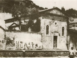
Unfortunately, the small church was destroyed along with most of the buildings in Zakynthos during the major earthquake that struck the Ionian Islands in 1953. Its ruins were then buried when the town was reconstructed, and its exact location was soon forgotten. Material evidence, local informants and cartographic data nevertheless point in the same direction: the church of Santa Maria delle Grazie would have been located in the northern sector of the modern town, around the current junction of Kolokotroni and Kolyva streets.
In order to assess the validity of this hypothesis, we called on the services of Geographic Information Systems (abbreviated GIS). GIS are computer-based tools used for the management, analysis, and display of geographically referenced information. Within the framework of the quest for Vesalius’ lost grave, they were used to overlay historical maps on modern cartographic data. The procedure, which is named geo-referencing, allows registering individual maps in a common geographic space so as to define their position in the real world. In the present case, the goal was to geo-reference a town map dated to 1892 and on which the church can be identified. See the accompanying photograph of the church.
However, since the coastline and the town plan drastically changed after the earthquake, it was not possible to overlay the particular map directly onto modern satellite images: intermediary steps were necessary. The methodology consisted therefore in travelling back in time and geo-referencing three available maps from the most recent to the oldest. The result of the process confirmed that the ruins of the Santa Maria delle Grazie are to be found to the northwest of the intersection of the current Kolyva and Kolokotroni streets. The road that ran in front of the church in the late 19th and early 20th century followed a different orientation than Kolyva street, with the consequence that the church lies partly below the street and partly below private properties.
This small GIS project represents only a first phase in the quest for Vesalius’ grave. Phase 2 would be to conduct a geophysical prospection at the Kolyva/Kolokotroni intersection. By making use of non-destructive geophysical methods, we could get an idea of what is still lying under the modern surface, and at which depth. This would provide a fast and high resolution understanding of the area. In an urban environment, two techniques can be used: Ground Penetrating radar and Electrical Resistivity Tomography, which measure the propagation of electromagnetic waves and of the electrical current in the ground, respectively. If the geophysical results were conclusive, the possibility of small-scale excavations (Phase 3) could be considered.
The GIS was sponsored by Agfa HealthCare, the Greek subsidiary of the Belgian Agfa Gevaert Group, the Belgian University of Antwerp, and Theo Dirix. For the consequent phases, Pascale Pollier offers to sell five original wax models of her facial reconstruction of Andreas Vesalius. This inversed reconstruction of Vesalius’s skull, based on his portrait, will have to suffice until we find his skull, allowing her to reconstruct his real face. Vesalius Continuum, initially the conference where we launched the search of Vesalius’s grave, has evolved in a programme to which you can contribute.
Personal note: My sincere thanks to Dr. Déderix, Pascale Pollier, and Theo Dirix for contributing this article to "Medical Terminology Daily" and the quest to find and study Andreas Vesalius' grave. I am proud to have been one of the many international attendees to the 2014 meeting in the island of Zakynthos. Dr. Miranda.

